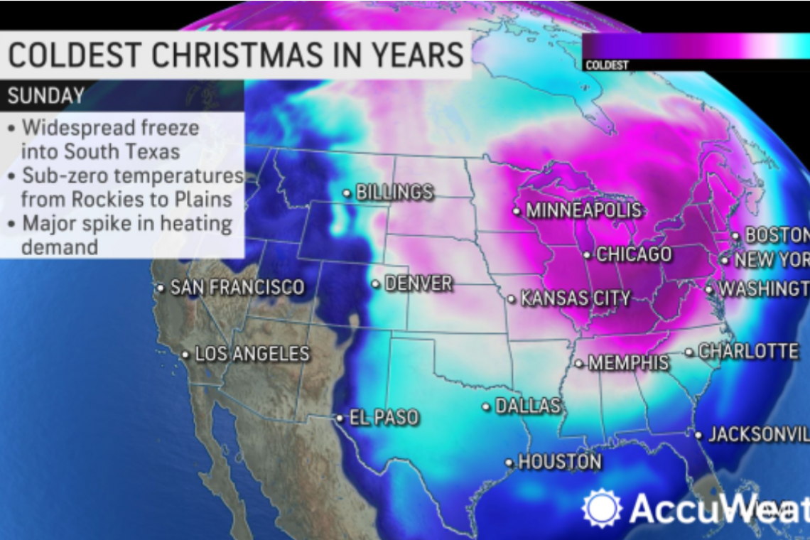
A bitter blast of cold air will flow into North America from Siberia is forecast to plunge the eastern two-thirds of the USA into a deep freeze in the days leading up to Christmas.
The cold could challenge records that have stood since the 1980s, as subzero temperatures are expected to grip states from the northern Rockies to the East. AccuWeather long-range forecasters expect the mercury to be up to 40 degrees Fahrenheit below late-December averages in parts of the country.
Siberia is one of the coldest locations on the planet during the winter months. Earlier this week, the mercury plunged to an incredible 78 degrees Fahrenheit below zero in the city of Yakutsk on Monday, according to AccuWeather lead international forecaster Jason Nicholls.
Good morning! -49C in #Yakutsk, #Russia, at 08:30 am. In some areas of the city, it was down to -53C.
— Bolot Bochkarev (@yakutia) December 13, 2022
Parabéns à Argentina! For making to the final #WorldcupQatar2022 pic.twitter.com/uIunl0ksr2
The intense cold will arrive in North America in two waves, as atmospheric energy moves it along through northeastern parts of Asia and into the northwestern part of North America next week.
RELATED Europe may have enough natural gas for frigid winter
"By early next week, the atmospheric energy bringing the cold will dive south out of the Gulf of Alaska and into the Pacific Northwest," said AccuWeather meteorologist Brandon Buckingham. It will then proceed through the northern Rockies and Upper Midwest from Monday to Tuesday. Low temperatures with this push of frigid air will not quite reach record levels, but low temperatures well below zero will be common in Montana and the Dakotas.
The subsequent push of cold air beginning in the middle of next week will make the first seem like an appetizer to the main course. The northern Rockies and northern Plains will bear the brunt of this bitter blast, which will try to expand south and east through the country in the days before Christmas.
"This could be one of the most extreme air masses that is observed all winter across portions of the north-central U.S.," Buckingham said. "I would not be surprised to see some areas in Montana or North Dakota approach 30 degrees Fahrenheit below zero, which would come close to some of the extreme cold observed back in 1983 and 1989."
Such temperatures would mean some of the coldest air on the planet will be in North America next week, as evidenced by how strong the cold area of high pressure, a bona fide piece of the polar vortex, is forecast to be in the northern Rockies. Some projections indicate the magnitude of the high pressure will be more than 1070 millibars (31.60 inches of mercury) over Montana. If that verifies, it would beat the old high-pressure record for the state, which is 1064 millibars (31.42 inches of mercury) set Christmas Eve 1983 in Miles City.
From there, the bitter cold will expand into the central and southern Plains and Midwest during the second half of the week, with the East getting a taste by the end of the week and next weekend. The cold will have staying power, lasting beyond Christmas.
"While the push of extreme cold will not last as long as the extreme push seen in February 2021, temperatures will likely not begin to rebound until about Dec. 27," said AccuWeather lead long-range forecaster Paul Pastelok.
That push of bitterly cold air in February 2021 stressed energy grids in the South, most notably in Texas, where there was a deadly, multiday power grid failure. "This round of cold will undoubtedly increase the energy demand across a wide swath of the nation due to the increased demand for heating purposes," Buckingham said.
This time around, Texans will likely find themselves shivering again. Low temperatures later next week are forecast to settle in the teens in Amarillo and in the lower 20s around Dallas. Near-freezing temperatures could also threaten crops in far southern Texas during Hanukkah and around Christmas.


