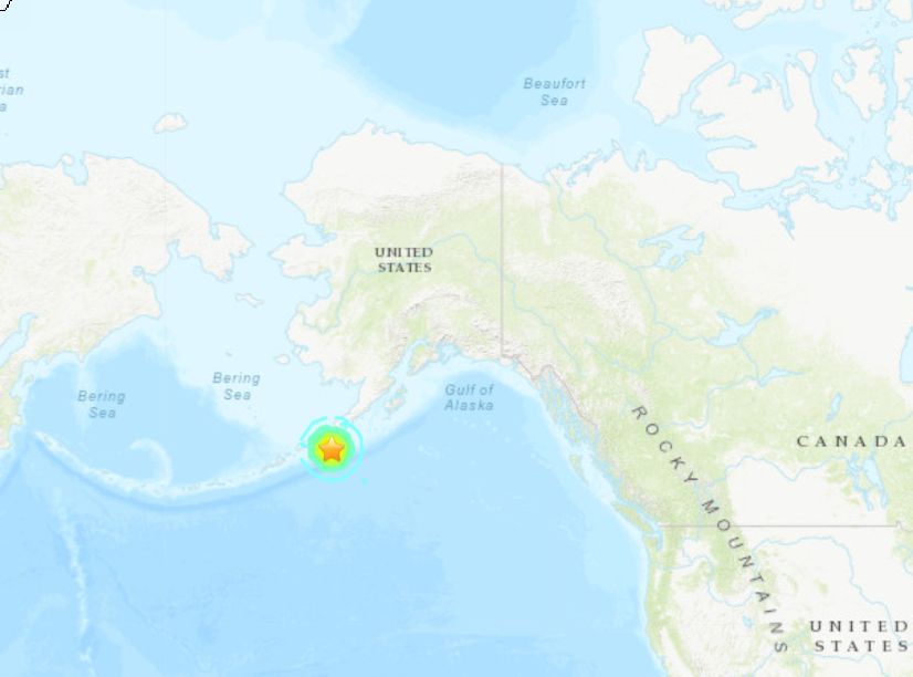
A large earthquake, with an initial Magnitude of 7.4, struck off the Aleutian Islands of Alaska at 2:48 AM eastern US time, generating TSUNAMI WARNINGS and EVACUATIONS along the Alaska Coast all the way to Anchorage.
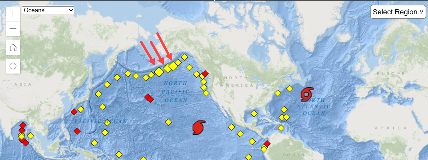
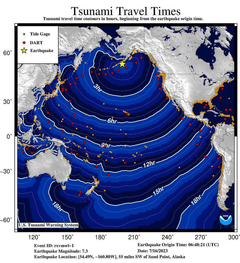
The quake struck in the Pacific Ocean as shown on the map below:
TSUNAMI WARNING BUOYS WENT INTO "EVENT" MODE:
TSUNAMI WARNINGS were issued:
WEAK51 PAAQ 160721
TSUAK1

BULLETIN
Public Tsunami Message Number 2
NWS National Tsunami Warning Center Palmer AK
1121 PM AKDT Sat Jul 15 2023

UPDATES
-------
 * Revised magnitude


...THE TSUNAMI WARNING REMAINS IN EFFECT...


Tsunami Warning in Effect for;

 * SOUTH ALASKA AND THE ALASKA PENINSULA, Pacific coasts from
   Kennedy Entrance, Alaska (40 miles SW of Homer) to Unimak
   Pass, Alaska (80 miles NE of Unalaska)


For other US and Canadian Pacific coasts in North America,
the level of tsunami danger is being evaluated.  Further
information will be provided in supplementary messages.


PRELIMINARY EARTHQUAKE PARAMETERS - UPDATED
-------------------------------------------

 * The following parameters are based on a rapid preliminary
   assessment of the earthquake and changes may occur.

 * Magnitude      7.4
 * Origin Time    2248 AKDT Jul 15 2023
                  2348  PDT Jul 15 2023
                  0648  UTC Jul 16 2023
 * Coordinates    54.5 North 160.8 West
 * Depth          13 miles
 * Location       55 miles SW of Sand Point, Alaska
                  615 miles SW of Anchorage, Alaska


FORECASTS OF TSUNAMI ACTIVITY
-----------------------------
 * Tsunami activity is forecasted to start at the following
   locations at the specified times.

                 FORECAST
                 START
SITE             OF TSUNAMI
----             ----------

 * Alaska
Sand Point       0010 AKDT Jul 16
Kodiak           0035 AKDT Jul 16
Cold Bay         0135 AKDT Jul 16


OBSERVATIONS OF TSUNAMI ACTIVITY
--------------------------------
 * No tsunami observations are available to report.


RECOMMENDED ACTIONS
-------------------
Actions to protect human life and property will
vary within tsunami warning areas.

If you are in a tsunami warning area;

 * Evacuate inland or to higher ground above and beyond
   designated tsunami hazard zones or move to an upper floor
   of a multi-story building depending on your situation.

 * Move out of the water, off the beach, and away from
   harbors, marinas, breakwaters, bays and inlets.

 * Be alert to and follow instructions from your local
   emergency officials because they may have more detailed or
   specific information for your location.

 * If you feel a strong earthquake or extended ground rolling
   take immediate protective actions such as moving inland
   and/or uphill preferably by foot.

 * Boat operators,
     * Where time and conditions permit, move your boat out to
       sea to a depth of at least 180 feet.

     * If at sea avoid entering shallow water, harbors,
       marinas, bays, and inlets to avoid floating and
       submerged debris and strong currents.

 * Do not go to the shore to observe the tsunami.

 * Do not return to the coast until local emergency officials
   indicate it is safe to do so.


IMPACTS
-------
Impacts will vary at different locations in the warning
areas.

If you are in a tsunami warning area;

 * A tsunami with damaging waves and powerful currents is
   possible.

 * Repeated coastal flooding is possible as waves arrive
   onshore, move inland, and drain back into the ocean.

 * Strong and unusual waves, currents and inland flooding
   can drown or injure people and weaken or destroy structures
   on land and in water.

 * Water filled with floating or submerged debris that can
   injure or kill people and weaken or destroy buildings and
   bridges is possible.

 * Strong and unusual currents and waves in harbors,
   marinas, bays, and inlets may be especially
   destructive.

 * Some impacts may continue for many hours to days after
   arrival of the first wave.

 * The first wave may not be the largest so later waves may
   be larger.

 * Each wave may last 5 to 45 minutes as a wave encroaches
   and recedes.

 * Coasts facing all directions are threatened because the
   waves can wrap around islands and headlands and into bays.

 * Strong shaking or rolling of the ground indicates an
   earthquake has occurred and a tsunami may be imminent.

 * A rapidly receding or receded shoreline, unusual waves and
   sounds, and strong currents are signs of a tsunami.

 * The tsunami may appear as water moving rapidly out to sea,
   a gentle rising tide like flood with no breaking wave,
   as a series of breaking waves, or a frothy wall of water.


ADDITIONAL INFORMATION AND NEXT UPDATE
--------------------------------------
 * Refer to the internet site tsunami.gov for more information.

 * Pacific coastal residents outside California, Oregon,
   Washington, British Columbia and Alaska should refer to the
   Pacific Tsunami Warning Center messages at tsunami.gov.

 * This message will be updated within 30 minutes.

$$
Video from inside a home showed the PANIC as the family felt the quake:
Video: The #Alaska #earthquake #Tsunami #EarthquakeReport pic.twitter.com/sCH2PVzo9N
— Waseem lazkani (@_Waseemlazkani) July 16, 2023
Social Media lit-up with citizens frightened that Tsunami Warning Sirens were sounding:
Ok Tsunami Sirens are now going off. People are starting to evacuate up the hillside. My town knows what to do and where to go.
— Alison S (@SOscarboy2) July 16, 2023
VIDEO with Tsunami Sirens Sounding, and INSTANT TRAFFIC JAMS!
Tsunami sirens in Kodiak Alaska #deprem #earthquake #alaska #tusunami #tsunami pic.twitter.com/yc0I8k8l1M
— Ozan.21 (@Ozan_krc21) July 16, 2023
Tsunami sirens in Kodiak, AK:
Tsunami sirens in kodiak after the earthquake#deprem #earthquake #alaska #tusunami #tsunami pic.twitter.com/nOMjH2MEpv
— Ozan.21 (@Ozan_krc21) July 16, 2023
More from Kodiak Island:
Siren going off#earthquake#Alaska#Tsunami pic.twitter.com/4CkjhElp3i
— World Military Index (@Tal614851771) July 16, 2023
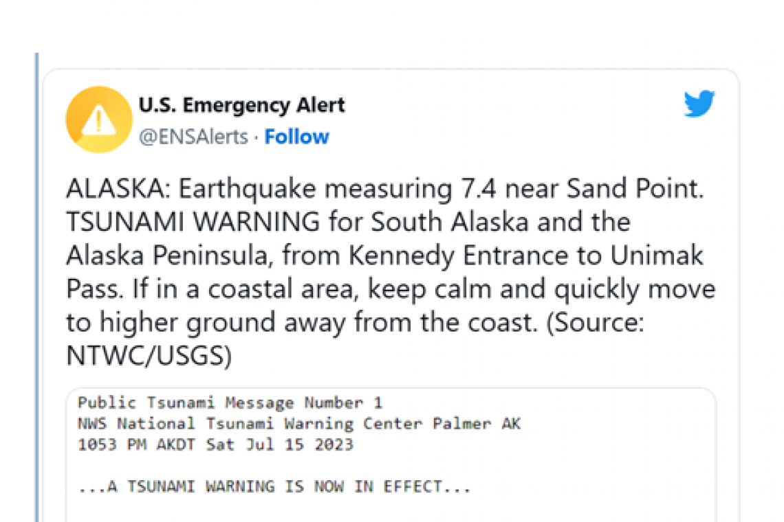
ALASKA: Earthquake measuring 7.4 near Sand Point. TSUNAMI WARNING for South Alaska and the Alaska Peninsula, from Kennedy Entrance to Unimak Pass. If in a coastal area, keep calm and quickly move to higher ground away from the coast. (Source: NTWC/USGS) pic.twitter.com/SopOCKeC5O
— U.S. Emergency Alert (@ENSAlerts) July 16, 2023
The National Weather Service reported "Significant inundation will take place OR IS ALREADY OCCURRING:
🌊A TSUNAMI WARNING has been issued for coastal Alaska, from Kennedy Entrance to Unimak Pass
— NWS Anchorage (@NWSAnchorage) July 16, 2023
❗ Significant inundation is possible or already occurring. Move inland to higher ground.
Estimated tsunami start times:
Sand Point 12:10 AM
Kodiak 12:35 AM
Cold Bay 1:35 AM pic.twitter.com/NwWZp6LGkt
It is worth noting that The 1946 Alaska Quake from this same area killed 159 people in Hilo, Hawaii, about 14 hours later….
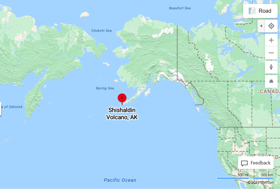
This earthquake and Tsunami are very likely RELATED to an explosive eruption of the Shishaldin Volcano, further southwest on the same fault line in the same Aleutian Islands. The explosive Eruption began yesterday:
#Shishaldin Aviation Color Code RED
— Alaska AVO (@alaska_avo) July 16, 2023
Issued: Saturday, July 15, 2023, 11:57 PM AKDT
The explosive eruption of Shishaldin Volcano is continuing. A continuous ash plume now extends over 80 mi (125 km) to the SSE from the volcano with an altitude of about 16,000 ft (4.9 km) asl 1/ pic.twitter.com/Ulcuk40i38
The map below shows the location of that volcano:
Pressure in the Tectonic Plates, where the North American Tectonic Plate meets the Pacific Tectonic Plate, (creating the "Ring of Fire" with earthquakes and volcanic eruptions), likely triggered the volcano to explode. When the pressure was released by the eruption, that allowed the plates to continue moving, which then likely triggered the earthquake in Alaska. It's all connected.
UPDATE 7:44 AM EDT --
As of 7:44 AM EDT, there have been eleven (11) earthquake aftershocks at the same of nearby location of the main quake. The aftershocks ARE continuing.

