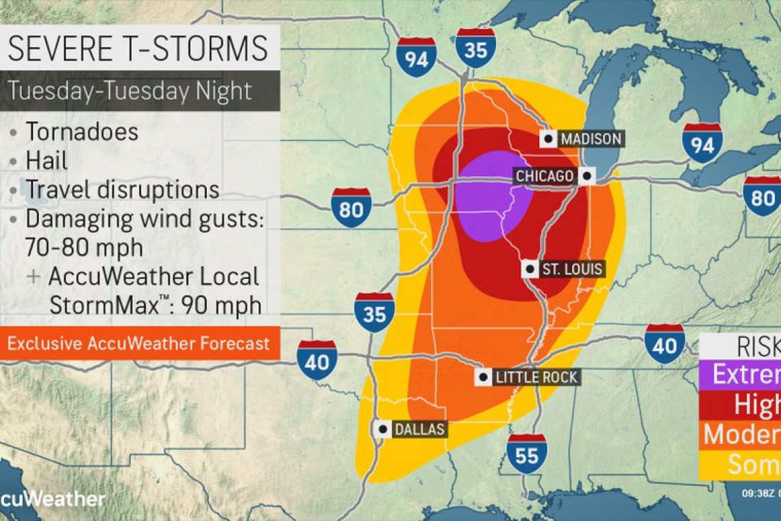
The US Storm Prediction Center is sounding the alarm that more -- and WORSE then last week -- Tornados are likely to strike Tuesday and Tuesday night in the US Midwest, as seen on the image above.
While last week's horrific tornado outbreak took place in a "Moderate" risk area, this latest forecast shows a worse set of conditions posing from "HIGH" to "EXTREME" RISK in portions of Missouri, Iowa and Illinois.
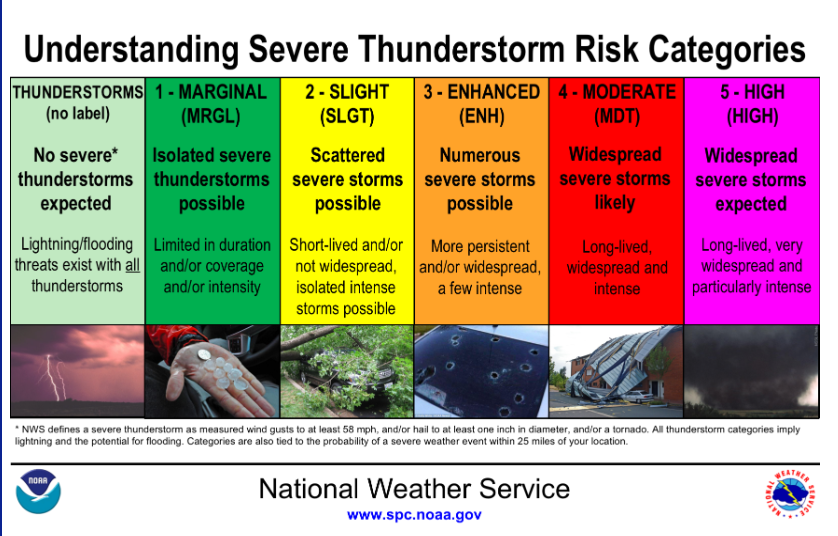
To better understand how the National Weather Service and its Storm Prediction Center rates these warnings, the chart below is helpful:
Severe Weather Risks
The level of categorical risk in the Day 1-3 Convective Outlooks is derived from probability forecasts of tornadoes, damaging winds, and large hail on Days 1 and 2, and a combined severe weather risk on Day 3.
- TSTM (light green) - General or non-severe thunderstorms - Delineates, to the right of a line, where a 10% or greater probability of thunderstorms is forecast during the valid period.
- 1-MRGL (dark green) - Marginal risk - An area of severe storms of either limited organization and longevity, or very low coverage and marginal intensity.
- 2-SLGT (yellow) - Slight risk - An area of organized severe storms, which is not widespread in coverage with varying levels of intensity.
- 3-ENH (orange) - Enhanced risk - An area of greater (relative to Slight risk) severe storm coverage with varying levels of intensity.
- 4-MDT (red) - Moderate risk - An area where widespread severe weather with several tornadoes and/or numerous severe thunderstorms is likely, some of which should be intense. This risk is usually reserved for days with several supercells producing intense tornadoes and/or very large hail, or an intense squall line with widespread damaging winds.
- 5-HIGH (magenta) - High risk - An area where a severe weather outbreak is expected from either numerous intense and long-tracked tornadoes or a long-lived derecho-producing thunderstorm complex that produces hurricane-force wind gusts and widespread damage. This risk is reserved for when high confidence exists in widespread coverage of severe weather with embedded instances of extreme severe (i.e., violent tornadoes or very damaging convective wind events).
Persons residing in the HIGH and EXTREME areas need to take precautions NOW. Don't wait. If you wait, you may be caught unprepared by the storms.
Clear your property of items that can be blown around by severe winds. Pack it away or tie it down.
Have a room or basement area inside your house to which you can retreat immediately should a tornado alert be sounded.
Stock that room or basement area with fresh water, edible food that does not require cooking. Board up windows to prevent flying glass, etc.,
Have a portable radio with fresh batteries to keep informed of news.
Have flashlights with fresh batteries.
Fully charge all phones.
Those of you who own generators, check their oil, put fresh fuel and test them TODAY.
HAVE A PLAN FOR YOUR FAMILY, especially what to do if things go bad and you are not all together. Where will you go instead of home? Where will you meet?
Pay very close attention to weather forecasts in your area and take action quickly to protect yourself and family if TORNADO EMERGENCIES ARE BROADCAST.
Please note: This web site does not usually address weather. The fact that it is addressing it now, ought to give you some idea of how bad things are appearing to become. This weather forecast is already heading toward "Historic" levels of severity.