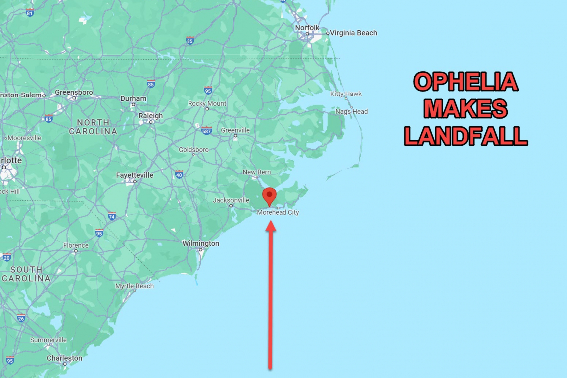
Tropical Storm Ophelia has made landfall in eastern North Carolina, jus slightly west of Morehead City, as seen on the map above. Tropical Storm Force winds extend 310 Niles in all directions from the center!
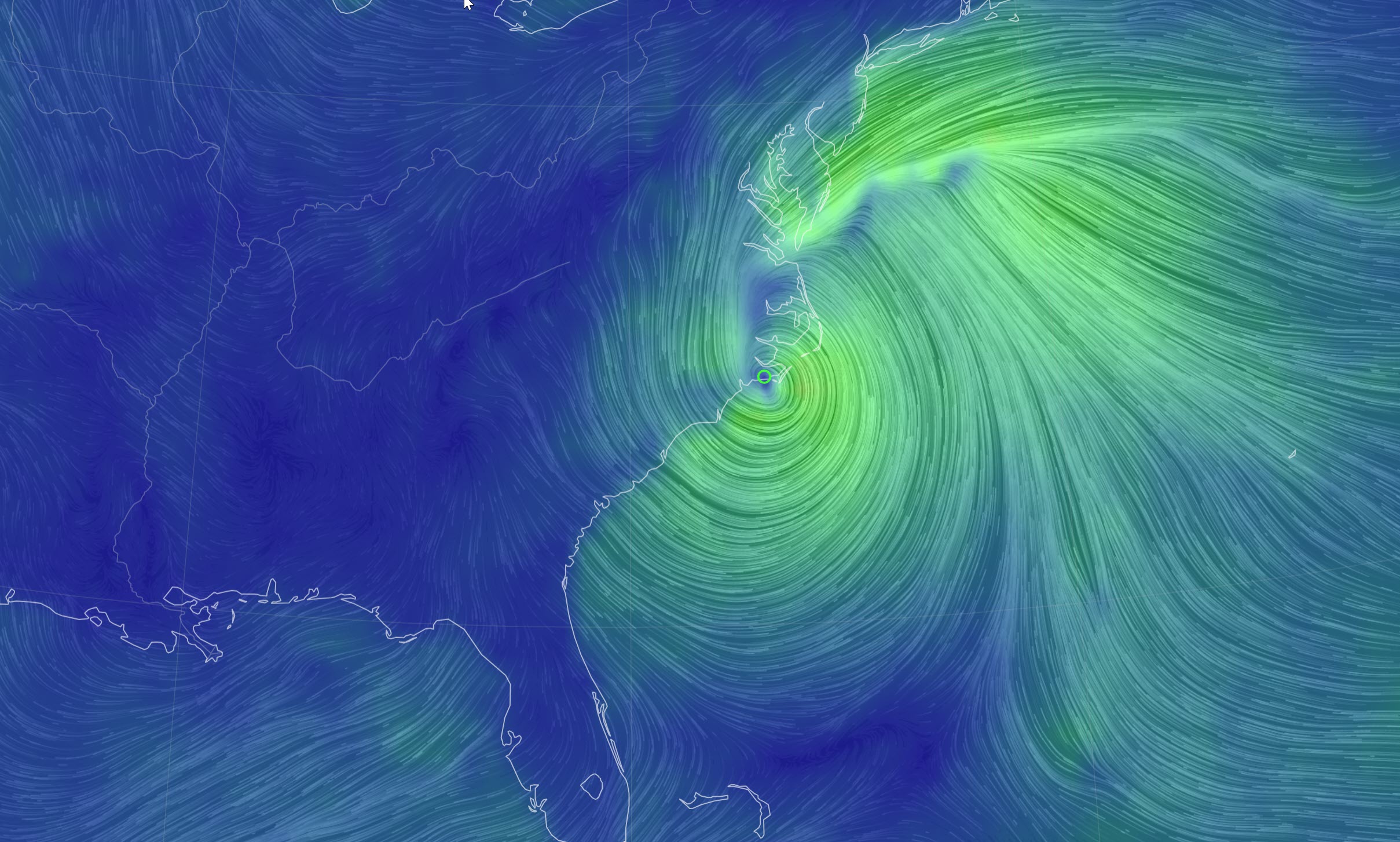
Data modeling from the GOES-5 satellite show the wind field map as of 7:00 AM EDT Saturday morning. The eye of the storm is at Morehead City North Carolina, but the wind field reaches all the way north into New Jersey!
From the National Hurricane Center:
015
WTNT31 KNHC 230849
TCPAT1

BULLETIN
Tropical Storm Ophelia Advisory Number   8
NWS National Hurricane Center Miami FL       AL162023
500 AM EDT Sat Sep 23 2023

...OPHELIA CLOSE TO LANDFALL IN NORTH CAROLINA...
...TROPICAL STORM CONDITIONS OCCURING ALONG THE COAST AND WILL
SPREAD NORTHWARD TODAY...


SUMMARY OF 500 AM EDT...0900 UTC...INFORMATION
----------------------------------------------
LOCATION...34.3N 76.9W
ABOUT 25 MI...45 KM SW OF CAPE LOOKOUT NORTH CAROLINA
ABOUT 70 MI...110 KM ENE OF CAPE FEAR NORTH CAROLINA
MAXIMUM SUSTAINED WINDS...70 MPH...110 KM/H
PRESENT MOVEMENT...NNW OR 345 DEGREES AT 9 MPH...15 KM/H
MINIMUM CENTRAL PRESSURE...981 MB...28.97 INCHES


WATCHES AND WARNINGS
--------------------
CHANGES WITH THIS ADVISORY:

None.

SUMMARY OF WATCHES AND WARNINGS IN EFFECT:

A Storm Surge Warning is in effect for...
* Bogue Inlet, North Carolina to Chincoteague, Virginia
* Chesapeake Bay south of Colonial Beach, Virginia
* Neuse and Pamlico Rivers
* Portions of Pamlico and Albemarle Sounds

A Storm Surge Watch is in effect for...
* Surf City, North Carolina to Bogue Inlet, North Carolina
* Remainder of Pamlico and Albemarle Sounds

A Hurricane Watch is in effect for...
* North of Surf City, North Carolina to Ocracoke Inlet, North
Carolina

A Tropical Storm Warning is in effect for...
* Cape Fear, North Carolina to Fenwick Island, Delaware
* Albemarle and Pamlico Sounds
* Tidal Potomac south of Cobb Island
* Chesapeake Bay south of North Beach

A Storm Surge Warning means there is a danger of life-threatening
inundation, from rising water moving inland from the coastline,
during the next 36 hours in the indicated locations. For a depiction
of areas at risk, please see the National Weather Service Storm
Surge Watch/Warning Graphic, available at hurricanes.gov.  This is a
life-threatening situation.  Persons located within these areas
should take all necessary actions to protect life and property from
rising water and the potential for other dangerous conditions.
Promptly follow evacuation and other instructions from local
officials.

A Hurricane Watch means that hurricane conditions are possible
within the watch area.

A Tropical Storm Warning means that tropical storm conditions are
expected somewhere within the warning area.

A Storm Surge Watch means there is a possibility of life-
threatening inundation, from rising water moving inland from the
coastline, in the indicated locations during the next 48 hours.
For a depiction of areas at risk, please see the National Weather
Service Storm Surge Watch/Warning Graphic, available at
hurricanes.gov.

For storm information specific to your area, including possible
inland watches and warnings, please monitor products issued by your
local National Weather Service forecast office.


DISCUSSION AND OUTLOOK
----------------------
At 500 AM EDT (0900 UTC), the center of Tropical Storm Ophelia was
located near latitude 34.3 North, longitude 76.9 West. Ophelia is
moving toward the north-northwest near 9 mph (15 km/h). A turn
toward the north is forecast later today, followed by a turn toward
the northeast on Sunday.  On the forecast track, the center of
Ophelia will reach the coast of North Carolina within the next
couple of hours, and then move across eastern North Carolina,
southeastern Virginia, and the Delmarva Peninsula the rest of today
and Sunday.

Maximum sustained winds are near 70 mph (110 km/h) with higher
gusts. Little change in strength is forecast before landfall along
the coast of North Carolina.  Weakening is expected after landfall
through the rest of the weekend, and Ophelia is likely to become an
extratropical cyclone tonight or Sunday morning.

Tropical-storm-force winds extend outward up to 310 miles (500 km)
from the center. NOAA buoy 41037 at Wrightsville Beach Offshore
recently reported a sustained wind of 54 mph (87 km/h) and a gust
to 83 mph (134 km/h). A sustained wind of 43 mph (68 km/h) and a
gust of 53 mph (85 km/h) was recently reported near Morehead City,
North Carolina.

The estimated minimum central pressure is 981 mb (28.97 inches)
based on aircraft reconnaissance data.


HAZARDS AFFECTING LAND
----------------------
Key messages for Ophelia can be found in the Tropical Cyclone
Discussion under AWIPS header MIATCDAT1, WMO header WTNT41 KNHC,
and on the web at hurricanes.gov/text/MIATCDAT1.shtml

STORM SURGE:  The combination of a dangerous storm surge and the
tide will cause normally dry areas near the coast to be flooded by
rising waters moving inland from the shoreline.  The water could
reach the following heights above ground somewhere in the indicated
areas if the peak surge occurs at the time of high tide...

Neuse and Bay Rivers...4-6 ft
Pamlico and Pungo Rivers...4-6 ft
Chesapeake Bay south of Colonial Beach...2-4 ft
Surf City, NC to Chincoteague, VA...2-4 ft
Albemarle Sound...2-4 ft
South Santee River, SC to Surf City, NC...1-3 ft
Chincoteague, VA to Manasquan Inlet, NJ...1-3 ft
Upper Chesapeake Bay...1-3 ft
Delaware Bay...1-3 ft

The deepest water will occur along the immediate coast in areas of
onshore winds, where the surge will be accompanied by dangerous
waves.  Surge-related flooding depends on the relative timing of the
surge and the tidal cycle, and can vary greatly over short
distances.  For information specific to your area, please see
products issued by your local National Weather Service forecast
office.

WIND:  Tropical storm conditions are affecting portions of the coast
of North Carolina and southeastern Virginia within the warning area
and will continue spreading northward today. Hurricane conditions
are possible within the watch area early this morning.

RAINFALL:  Ophelia is expected to produce the following rainfall:

Across portions of eastern North Carolina and southeast Virginia…3
to 5 inches with isolated higher totals around 8 inches into Sunday
morning.

Across the remaining portions of the Mid Atlantic…2 to 4 inches
tonight through Sunday.

Across southern New York through southern New England…1 to 3 inches
Saturday into Monday.

This rainfall may produce locally considerable flash, urban, and
small stream flooding impacts, particularly across the Mid Atlantic
region from North Carolina to New Jersey. Isolated river flooding is
possible in areas of heavier rainfall.

SURF:  Swells generated by Ophelia will affect much of the east
coast of the United States through this weekend.  These swells are
likely to cause life-threatening surf and rip current conditions.
Please consult products from your local weather office.

TORNADOES:  A tornado or two may occur today over parts of the
Mid-Atlantic Coast.


NEXT ADVISORY
-------------
Next intermediate advisory at 800 AM EDT.
Next complete advisory at 1100 AM EDT.

$$
Forecaster Kelly/Cangialosi


