 English
 العربية
 Български
 简体中文
简体中文 Hrvatski
 Čeština
 Dansk
Dansk Nederlands
 Suomi
Suomi Français
 Deutsch
 Ελληνικά
 हिन्दी
 Italiano
 日本語
日本語 한국어
한국어 Norsk bokmål
 Polski
 Português
 Română
 Русский
 Español
 Svenska
 Filipino
 עִבְרִית
 Bahasa Indonesia
 Latviešu valoda
 Lietuvių kalba
 Српски језик
 Slovenčina
 Slovenščina
 Українська
 Tiếng Việt
 Shqip
Shqip Eesti
Eesti Galego
 Magyar
 ไทย
ไทย Türkçe
 فارسی
فارسی Afrikaans
 Gaeilge
 Cymraeg
 Беларуская мова
 Íslenska
 Македонски јазик
 יידיש
יידיש Հայերեն
 Azərbaycan dili
 ქართული
 Kreyol ayisyen
 اردو
اردو বাংলা
বাংলা Bosanski
 Hmong
Hmong Basa Jawa
 ພາສາລາວ
 Te Reo Māori
 Монгол
 नेपाली
 Afsoomaali
 ဗမာစာ
ဗမာစာ Қазақ тілі
 മലയാളം
 Sesotho
 Basa Sunda
 Тоҷикӣ
 O‘zbekcha
 Corsu
Corsu Ōlelo Hawaiʻi
 كوردی
كوردی Кыргызча
 Lëtzebuergesch
 پښتو
پښتو Samoan
 Gàidhlig
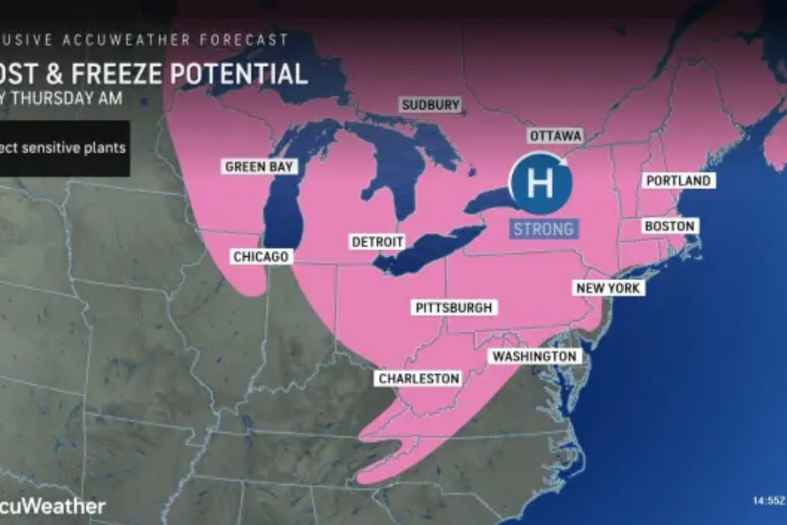
Garden centers, agricultural interests, or anyone who has put out tender plants in areas where a frost or freeze can occur from Wednesday night to Friday morning will be at risk. Then the violent Thunderstorms come . . .
The first of two Canadian high-pressure areas delivered temperatures in the frosty mid- to upper 20s from interior southern Michigan to northern Ohio, central Pennsylvania, central and southern New York state and central and northern New England.
The cold air and threat of frosts and freezes have sent orchard and vineyard operators scrambling to raise temperatures by a few degrees by using wind machines and bonfires in their fields. Regarding vineyards, the non-native varieties of grapes are most susceptible to damage.
"Widespread low temperatures in the 20s to the low 30s are in store from much of the Great Lakes region [away from the immediate shores of the lakes] to the central Appalachians, the interior mid-Atlantic and much of New England on Thursday morning," AccuWeather senior meteorologist Matt Benz said.
Also, the urban "heat island" effect may prevent frost in some large cities but only to a certain point. There is the risk of frost reaching some coastal areas of the Northeast on Thursday and Friday mornings, including in Boston and Philadelphia, as well as New York City and Washington, D.C. Frost is a concern around Chicago, Detroit, Cleveland and Pittsburgh -- at least for Thursday morning.
As a special note, forecast low temperatures are intended for a location 4-6 feet off the ground, where official temperature readings are taken. During a clear, calm night, the temperatures can dip 5-10 degrees lower at ground level compared to 4-6 feet above the ground. In conditions such as those anticipated in the region from Wednesday night and Thursday night, it may be necessary to subtract at least 5 degrees from the forecast low temperature for a more accurate reading at ground level.
As the leading edge of the cold air pushes in, temperatures may dip low enough as moisture lingers for a mixture of rain and snow over the mountains of the northern tier of the Northeast from Tuesday night to Wednesday, Benz explained.
"Up to a few inches of snow may fall from parts of the Green and White Mountains to northern Maine from late Tuesday night to Wednesday," Benz said.
Farther to the south, the same cold front responsible for the snow over the northern tier will set off showers and locally heavy thunderstorms over parts of the Midwest on Tuesday afternoon and evening.

On Wednesday, the same cold front may set off locally strong thunderstorms in parts of the mid-Atlantic.