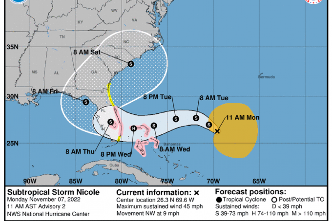
Another Hurricane is forecast to hit Florida, this one to make landfall in southeast Florida Wednesday night-into-Thursday morning.
The National Hurricane Center reports as follows:
000
WTNT32 KNHC 071747
TCPAT2

BULLETIN
Subtropical Storm Nicole Intermediate Advisory Number 2A
NWS National Hurricane Center Miami FL       AL172022
200 PM AST Mon Nov 07 2022

...LARGE NICOLE MOVING NORTHWESTWARD WITH NO CHANGE IN STRENGTH...


SUMMARY OF 200 PM AST...1800 UTC...INFORMATION
----------------------------------------------
LOCATION...26.4N 70.1W
ABOUT 465 MI...750 KM E OF THE NORTHWESTERN BAHAMAS
MAXIMUM SUSTAINED WINDS...45 MPH...75 KM/H
PRESENT MOVEMENT...NW OR 315 DEGREES AT 9 MPH...15 KM/H
MINIMUM CENTRAL PRESSURE...1001 MB...29.56 INCHES


WATCHES AND WARNINGS
--------------------
CHANGES WITH THIS ADVISORY:

None

SUMMARY OF WATCHES AND WARNINGS IN EFFECT:

A Hurricane Watch is in effect for...
* Northwestern Bahamas
* East Coast of Florida from the Volusia/Brevard County Line to
Hallandale Beach
* Lake Okeechobee

A Storm Surge Watch is in effect for...
* Altamaha Sound to Hallandale Beach

A Tropical Storm Watch is in effect for...
* Altamaha Sound southward to the Volusia/Brevard County Line
* Hallandale Beach to north of Ocean Reef

A Tropical Storm Watch means that tropical storm conditions are
possible within the watch area, generally within 48 hours.

A Hurricane Watch means that hurricane conditions are possible
within the watch area.  A watch is typically issued 48 hours
before the anticipated first occurrence of tropical-storm-force
winds, conditions that make outside preparations difficult or
dangerous.

Interests in the central Bahamas, the remainder of Florida, and
along the southeastern coast of the United States should monitor
the progress of Nicole. Additional watches or warnings will likely
be required later today or tonight.

For storm information specific to your area in the United
States, including possible inland watches and warnings, please
monitor products issued by your local National Weather Service
forecast office. For storm information specific to your area
outside of the United States, please monitor products issued by
your national meteorological service.


DISCUSSION AND OUTLOOK
----------------------
At 200 PM AST (1800 UTC), the center of Subtropical Storm Nicole was
located near latitude 26.4 North, longitude 70.1 West. The storm
is moving toward the northwest near 9 mph (15 km/h). A slower
northwestward motion is expected later this afternoon through
tonight. A turn toward the west or west-southwest is then forecast
to begin by Tuesday night and that motion should continue through
early Thursday. On the forecast track, the center of Nicole will
approach the northwestern Bahamas on Tuesday and Tuesday night,
move near or over those islands on Wednesday, and approach the east
coast of Florida Wednesday night.

Maximum sustained winds are near 45 mph (75 km/h) with higher
gusts. Gradual strengthening is forecast during the next few days,
and Nicole is forecast to be at or near hurricane intensity by
Wednesday or Wednesday night while it is moving near or over the
northwestern Bahamas.

Winds of 40 mph extend outward up to 275 miles (445 km) from the
center.

The estimated minimum central pressure is 1001 mb (29.56 inches).


HAZARDS AFFECTING LAND
----------------------
Key messages for Nicole can be found in the Tropical Cyclone
Discussion under AWIPS header MIATCDAT2, WMO header WTNT42 KNHC,
and on the web at www.hurricanes.gov/text/MIATCDAT2.shtml.

WIND:  Hurricane conditions are possible within the watch area in
the northwest Bahamas by early Wednesday, with tropical storm
conditions possible by Tuesday night. Hurricane conditions are
possible within the watch area in Florida by Wednesday night with
tropical storm conditions possible by Tuesday night.

STORM SURGE:  The combination of a dangerous storm surge and the
tide will cause normally dry areas near the coast to be flooded by
rising waters moving inland from the shoreline.  The water could
reach the following heights above ground somewhere in the indicated
areas if the peak surge occurs at the time of high tide...

*North Palm Beach to Altamaha Sound including the St. Johns
River to the Fuller Warren Bridge... 3 to 5 ft
*Hallandale Beach to North Palm Beach...2 to 4 ft
*North of Ocean Reef to Hallandale Beach including Biscayne Bay...1
to 2 ft

Storm surge could raise water levels by as much as 3 to 5 feet
above normal tide levels along the immediate coast of the
northwestern Bahamas in areas of onshore winds.

The deepest water will occur along the immediate coast near and to
the north of the landfall location, where the surge will be
accompanied by large and destructive waves.  Surge-related
flooding depends on the relative timing of the surge and the tidal
cycle, and can vary greatly over short distances.  For information
specific to your area, please see products issued by your local
National Weather Service forecast office.

RAINFALL:  Nicole is expected to produce the following rainfall
amounts through Thursday:

Across the northwest Bahamas, and the central and northern portions
of the Florida Peninsula: 2 to 4 inches, with local maxima of 6
inches

Heavy rainfall from this system will spread north across the
Southeast United States late this week.


NEXT ADVISORY
-------------
Next complete advisory at 500 PM AST.


