From the National Hurricane Center -- Possible TEXAS / LOUISIANA Hit. See bottom . . .
000
WTNT32 KNHC 031149
TCPAT2

BULLETIN
Hurricane Beryl Intermediate Advisory Number 19A
NWS National Hurricane Center Miami FL       AL022024
800 AM EDT Wed Jul 03 2024

...BERYL EXPECTED TO BRING HURRICANE CONDITIONS TO JAMAICA BY
MIDDAY TODAY WITH LIFE-THREATENING WINDS AND STORM SURGE...
...EXPECTED TO APPROACH THE CAYMAN ISLANDS TONIGHT INTO THURSDAY...


SUMMARY OF 800 AM EDT...1200 UTC...INFORMATION
----------------------------------------------
LOCATION...16.9N 75.3W
ABOUT 125 MI...200 KM SE OF KINGSTON JAMAICA
ABOUT 430 MI...690 KM ESE OF GRAND CAYMAN
MAXIMUM SUSTAINED WINDS...145 MPH...230 KM/H
PRESENT MOVEMENT...WNW OR 285 DEGREES AT 20 MPH...31 KM/H
MINIMUM CENTRAL PRESSURE...952 MB...28.11 INCHES


WATCHES AND WARNINGS
--------------------
CHANGES WITH THIS ADVISORY:

None.

SUMMARY OF WATCHES AND WARNINGS IN EFFECT:

A Hurricane Warning is in effect for...
* Jamaica
* Grand Cayman
* Little Cayman and Cayman Brac

A Hurricane Watch is in effect for...
* South coast of Haiti from the border with the Dominican
Republic to Anse d'Hainault
* East coast of the Yucatan Peninsula from Chetumal to Cabo Catoche

A Tropical Storm Warning is in effect for...
* South coast of Dominican Republic from Punta Palenque westward
to the border with Haiti
* South coast of Haiti from the border with the Dominican
Republic to Anse d'Hainault

A Tropical Storm Watch is in effect for...
* Coast of Belize from south of Chetumal to Belize City

A Hurricane Warning means that hurricane conditions are expected
somewhere within the warning area.  Preparations to protect life
and property should be rushed to completion.

A Tropical Storm Warning means that tropical storm conditions are
expected somewhere within the warning area within 36 hours.

A Hurricane Watch means that hurricane conditions are possible
within the watch area, generally within 48 hours.

A Tropical Storm Watch means that tropical storm conditions are
possible within the watch area, generally within 48 hours.

Interests elsewhere in the northwestern Caribbean Sea and the
western Gulf of Mexico should closely monitor the progress of Beryl.

For storm information specific to your area, please monitor
products issued by your national meteorological service.


DISCUSSION AND OUTLOOK
----------------------
At 800 AM EDT (1200 UTC), the eye of Hurricane Beryl was located
near latitude 16.9 North, longitude 75.3 West. Beryl is moving
toward the west-northwest near 20 mph (31 km/h), and this general
motion should continue through today, followed by a turn more toward
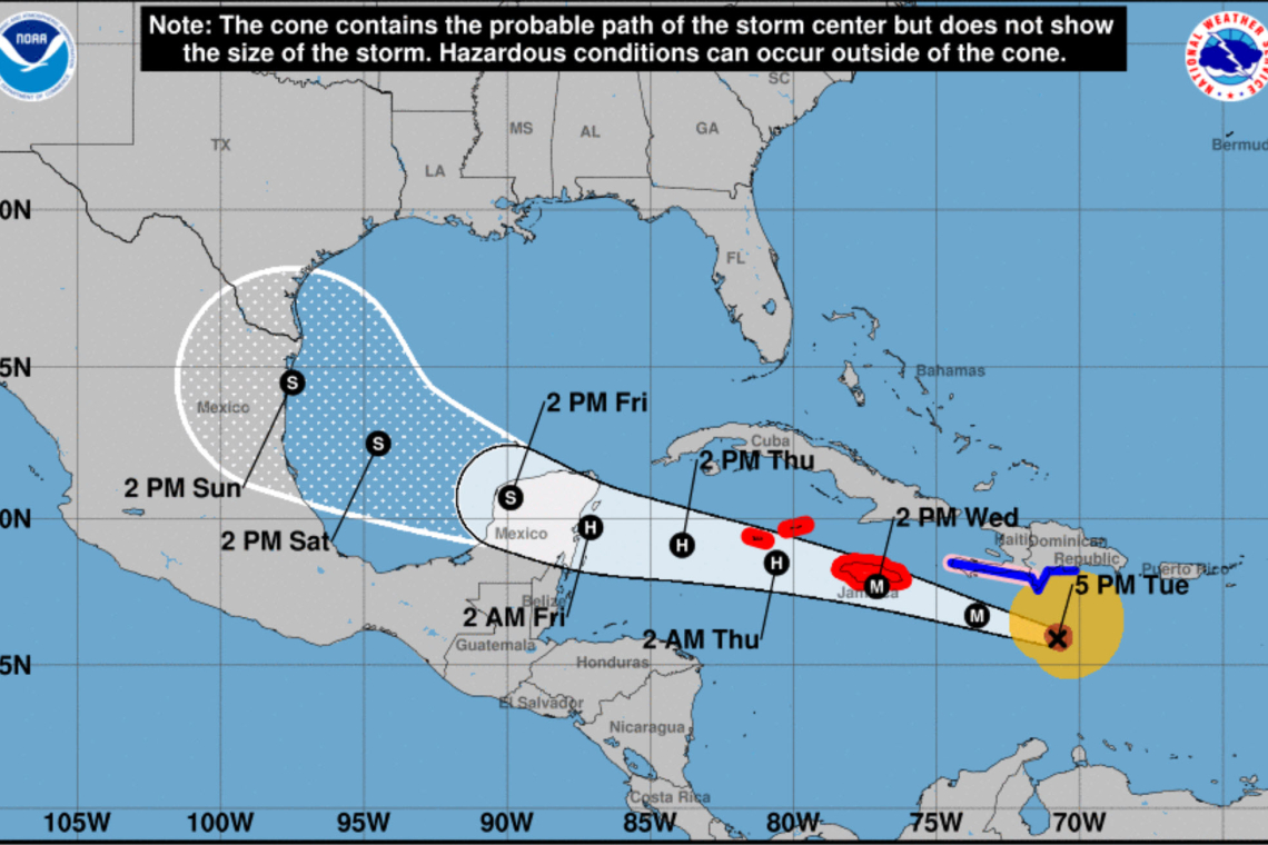
the west tonight or Thursday.  On the forecast track, the center of
Beryl will move rapidly across the central Caribbean Sea and is
forecast to pass near or over Jamaica later today.  The center is
expected to pass near or over the Cayman Islands tonight or early
Thursday and move over the Yucatan Peninsula of Mexico early Friday.

Reports from NOAA and Air Force Reserve Hurricane Hunter aircraft
indicate that maximum sustained winds are near 145 mph (230 km/h)
with higher gusts.  Beryl is a category 4 hurricane on the
Saffir-Simpson Hurricane Wind Scale.  Some weakening is forecast
during the next day or two.  However, Beryl is forecast to be at or
near major hurricane intensity while it passes near Jamaica later
today and the Cayman Islands tonight or early Thursday. Additional
weakening is expected thereafter, though Beryl is forecast to
remain a hurricane in the northwestern Caribbean.

Hurricane-force winds extend outward up to 45 miles (75 km) from
the center and tropical-storm-force winds extend outward up to 185
miles (295 km).

The latest minimum central pressure reported by the Hurricane
Hunter aircraft is 952 mb (28.11 inches).


HAZARDS AFFECTING LAND
----------------------
Key messages for Beryl can be found in the Tropical Cyclone
Discussion under AWIPS header MIATCDAT2 and WMO header WTNT42 KNHC.

WIND:  Hurricane conditions are expected to reach the coast of
Jamaica within the warning area around midday.  Winds are expected
to first reach tropical storm strength during the next several
hours, making outside preparations difficult or dangerous.

Wind speeds atop and on the windward sides of hills and mountains
are often up to 30 percent stronger than the near-surface winds
indicated in this advisory, and in some elevated locations could be
even greater.

Hurricane conditions are expected to reach the Cayman Islands
tonight or early Thursday.  Winds are expected to first reach
tropical storm strength late this afternoon, making outside
preparations difficult or dangerous.

Hurricane conditions are possible along portions of the east coast
of the Yucatan Peninsula as early as late Thursday.

Tropical storm conditions are expected in the warning area along the
south coast of Hispaniola today.

Tropical storm conditions are possible along portions of the coast
of Belize by late Thursday or early Friday.

STORM SURGE:  Storm surge could raise water levels by as much as 6
to 9 feet above normal tide levels in areas of onshore winds along
the immediate coast of Jamaica.

Storm surge could raise water levels by as much as 2 to 4 feet above
normal tide levels in areas of onshore winds along the immediate
coast of the Cayman Islands.

Storm surge could raise water levels by as much as 1 to 3 feet above
ground level in areas of onshore winds along the southern coast of
Hispaniola.

Storm surge could raise water levels by as much as 3 to 5 feet
above ground level in areas of onshore winds along the east coast of
the Yucatan Peninsula within the hurricane watch area.

Near the coast, the surge will be accompanied by large and
destructive waves.

RAINFALL:  Beryl is expected to produce rainfall totals of 4 to 8
inches, with localized amounts of 12 inches, across Jamaica through
this evening along with additional rainfall of 4 to 6 inches over
the Tiburon Peninsula of Haiti. This heavy rainfall is expected to
cause life-threatening flash flooding and mudslides.

Beryl is expected to produce rainfall totals of 2 to 4 inches with
localized maxima of 6 inches over the Cayman Islands tonight into
Thursday. Over the Yucatan Peninsula into northern Belize, Beryl is
expected to produce rainfall totals of 2 to 6 inches with localized
amounts of 8 inches, along with at least localized flash flooding,
late Thursday through Friday.

For a complete depiction of forecast rainfall and flash flooding
associated with Hurricane Beryl, please see the National Weather
Service Storm Total Rainfall Graphic, available at
hurricanes.gov/graphics_at2.shtml?rainqpf

SURF:  Large swells generated by Beryl are impacting the southern
coasts of Puerto Rico, Hispaniola, and Jamaica and are expected to
impact the Cayman Islands later today through midweek.  Swell will
continue to affect the Windward and Leeward Islands during the next
day or so.  These swells are expected to cause life-threatening surf
and rip current conditions. Please consult products from your local
weather office.


NEXT ADVISORY
-------------
Next complete advisory at 1100 AM EDT.

$$
Forecaster Beven

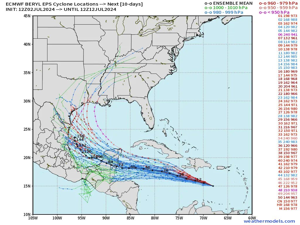
FORECAST COMPUTER MODELS - Texas / Louisiana

Forecast MODELS are now showing a potential for Hurricane Beryl to turn northward late this week into early next week,
and possibly strike TEXAS or LOUISIANA:


